Protecting and managing habitat
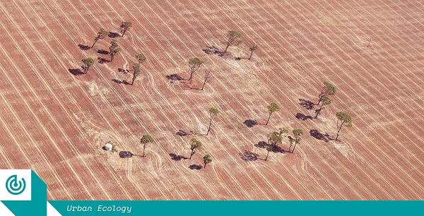
Here is the full story from foreground.com.au – High water: How design might help fix the Wheatbelt’s water woes
Agricultural land in one of Australia’s most important rural economies is trapped in a cycle of continuous degeneration. Could the implementation of a more carefully designed and planned landscape ecology prevent catastrophe?
This article is part of Foreground’s Urban Ecology special series.
Growing up on a broadacre cropping farm water was always central to my family’s life and livelihood. My childhood was spent leaning on the western fence, holding my breath and crossing my fingers that the front rolling in from the North West would make it as far as our place at the foot of the Wongan Hills. Now a practising landscape architect in Fremantle, I can’t seem to shake the habit. I still scan the horizon for an impending front, and take note of wind direction. My UDLA colleagues call me “the weather girl”. Although always close to the environment around me, my childhood perspective was one of intimate, subjective knowledge of place. Studying landscape architecture taught me to think objectively. I began to see through the landscape I had always known and loved, to the underlying problems below. I began to question our farming practices and processes, and came to the realisation that not only was the land sick, it was stuck in a cycle of continuous degeneration. This realisation unfortunately came too late: the farm had by then become unviable, and we sold up in my final year at university. Nevertheless, it led to an honours thesis entitled Ameliorating Agriculture, Cultivating Biodiversity, which subsequently became the impetus for a field trip I recently completed along the Gondwana Link as part of a travel scholarship.
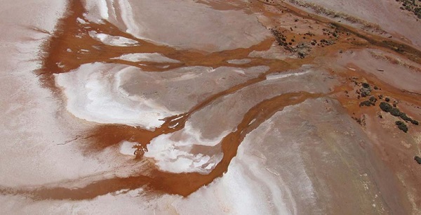
The draining of the Wheatbelt’s aquifer is happening at a rate that could be unsustainable in the long term.
The net effect of all this change is a highly volatile environment for farming, which already involves a precarious guessing game, marrying weather estimates and investment to achieve a margin that allows a farmer to do it all again the next year. The surging cost of investment inputs, such as fuel and synthetic fertiliser, coupled with low grain prices and increasingly erratic and unpredictable rainfall events, are tightening that margin.
The farming economy revolves around efficiency: achieving the highest yield with the least input. To stay viable within current agricultural conditions, farmers need to increase the area of land farmed, to generate greater efficiency. Technology is evolving to support this expansion, with the size of machinery increasing to service larger farms, equipped with technology to map and monitor yields, and customise inputs accordingly. This increase in scale is having an adverse effect on rural communities, with a net reduction in employment pushing the workforce off the land and into the cities.
The landscape is also suffering, as both fence lines and single paddock trees are cleared to facilitate the movement of larger machinery, removing important habitat. The application of synthetic fertiliser is causing acidification of soil, while regular herbicide application has led to herbicide resistance in many weed species. Wide expanses of bare paddocks are stripped of their top soil during summer’s strong easterly winds. So, while current practices are designed to be more efficient, they are also accelerating the degradation of the environment.
Could technology-driven efficiencies be integrated to establish a regenerative synergy between agricultural and ecological landscapes?
Keeping water “high in the landscape”
In acknowledging that my original research in this area was driven by an ambition to redesign the way the family farm worked, from a degenerative system into regenerative one, the sale of the farm meant shifting focus. I reframed my research to investigate farming practices at a regional and catchment scale throughout the Wheatbelt. With this, my research started to look at emerging precision agriculture, including water use efficiency yield mapping, and controlled traffic farming. Could such technology-driven efficiencies be integrated into environmental and ecological system design, to establish a regenerative synergy between agricultural and ecological landscapes?
Put simply, precision agriculture aims to improve a farmer’s ability to manage variables within a paddock. It provides tools to quantify soil, terrain and crop variability, allowing farmers to customise agronomic applications and practices to better suit these variables. Water use efficiency yield mapping is a method of measuring how efficiently a crop has yielded with regard to the amount of rain that fell in the associated growing season. Rather than comparing the yield of one year to the next, in which the total rainfall always varies, this method projects a maximum yield which could be achieved for that season’s rainfall, allowing for a base line for input improvement and refinement.
I also looked into how uncontrolled farm traffic creates farmland compaction. Farm vehicles and machinery have varied wheel bases and spreads, the movements of which means that on average 85 percent of the paddock is compacted by wheel tracks each year. The compaction of soil reduces permeability for both water and the root structure of plants, which increases runoff while limiting growth. Controlled traffic farming (CTF) aims to divide paddocks into two sections: a healthy well-structured soil for promoting crop growth, and a track for supporting vehicles and machinery. By regulating the wheel base and spread of farm machinery, and with informed design and “deep ripping” to mechanically aerate soil, wheel compaction can be limited to 10 percent of the paddock. This can increase water penetration by 80 percent.
This research required an extensive review of literature and graphic mapping of the problems associated with the health of both the ecological and agricultural systems: an analytical approach that followed in the footsteps of Ian McHarg, who established the principles of geographic information systems almost half a century ago. It involved spatially mapping layers of information and ideas individually, then overlaying them to guide the design outcome. Through this process, several series of mapping data were generated to analyse the vegetation complex, hydrology, salinity, topography, geology and agricultural processes and practices. This was carried out at both the farm scale and within the Wongan-Ballidu region.
After analysing the local ecological and agricultural systems and processes separately, it became apparent that the degenerating health of farms and the associated environmental problems could not be viewed as separate entities. These processes are closely entwined, with water as the key element binding the future of farming in the Wheatbelt.
A deceptively simple conclusion emerged from this research: water needs to be kept high in the landscape. Keeping water high means to absorb rainfall before it becomes runoff, using the slope of the land to determine how the farming system operates. This includes redefining smaller paddocks that respond to topography and machinery dimensions, rather than surveyed boundaries on a map. By using revegetation belts to reconnect fragmented bushland along contour banks, these belts become shelter belts for native animals or livestock, while capturing runoff and providing a buffer for reducing evaporation and wind erosion. Keeping water high also allows deep rooted trees to soak up excess runoff and help lower the water table, mitigating the effects of salinity.